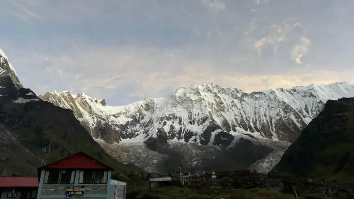
Annapurna Base Camp (ABC) stands at 4,130 meters (13,550 feet) above sea level. But knowing the final elevation alone doesn't tell you how demanding the trek will feel.
What matters is how quickly you gain altitude, where the major elevation changes occur, and how your body may respond as you climb. Understanding the elevation profile helps you plan your daily stages, prepare for thinner air, and recognize the risks of altitude sickness.
This guide breaks down the elevation at each major stop on the ABC Trek, the total elevation gain, and what the changing altitude means for your trek.
Annapurna Base Camp Trek Elevation Profile (Meters & Feet)
Stop-by-Stop Elevation Chart: Trailhead to Annapurna Base Camp
| Day | Trek Section | Sleeping Elevation (m) | Sleeping Elevation (ft) | Elevation Gain/Loss |
|---|---|---|---|---|
| 1 | Nayapul to Tikhedhunga | 1,577 | 5,174 | +507 m |
| 2 | Tikhedhunga to Ghorepani | 2,855 | 9,367 | +1,278 m |
| 3 | Ghorepani via Poon Hill to Tadapani | 2,610 | 8,563 | −245 m |
| 4 | Tadapani to Chhomrong | 2,170 | 7,119 | −440 m |
| 5 | Chhomrong to Himalaya | 2,880 | 9,449 | +710 m |
| 6 | Himalaya to Annapurna Base Camp | 4,130 | 13,550 | +1,250 m |
| 7 | Annapurna Base Camp to Bamboo | 2,310 | 7,579 | −1,820 m |
| 8 | Bamboo to Jhinu Danda | 1,780 | 5,840 | −530 m |
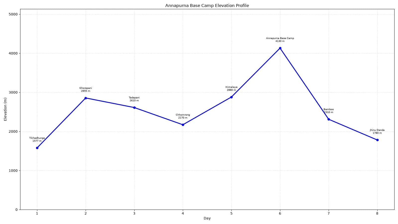
Elevation profile of the Annapurna Base Camp trek, tracking altitude progression from Tikhedhunga (1,577 m) to the maximum elevation at Annapurna Base Camp (4,130 m).
Annapurna Base Camp Trek has several starting points depending on the itinerary. Some of the common starting points are Nayapul (1,070 m), Siwai (1,395 - 1,530 m ), Ghandruk (1,940 - 2,012 m) and Jhinu Danda (1,780 m).
The above table follows a itinerary starting from Nayapul, which is suitable for trekkers who wants to enjoy the trek at a comfortable pace. Looking at the table, you can see that the elevation gain is not always positive. Before reaching ABC, you have stops like Tadapani and Chhomrong, where you will sleep at lower altitudes than at the previous stops.
We also hike from Ghorepani to Poon Hill (3,210 m), which is the first time you reach the elevation above 3,000 m. In the above table, we are using sleeping elevation as it is more important when considering altitude sickness risk.
Additionally, the positive and negative elevation gain doesn't mean that there will be continuous ascent or descent throughout that day. The trail often includes both climbs and descents, even on the day when the overall change is positive or negative. So, don't assume that positive elevation means harder days and negative means easier ones.
Total Elevation gain from Nayapul to Annapurna Base Camp.
The net elevation gain from Nayapul to ABC is around 3,060 m (10,039 ft). However, this represents the difference in elevation between the two locations, not the exact elevation gain throughout the trek. Since the trail repeatedly gains or loses elevation, the cumulative elevation gain is generally higher. If we include all the major stops between Nayapul to Annapurna Base Camp, the cumulative gain is over 4,100 m.
Difficult Parts of the Annapurna Base Camp Trek
Tikhedhunga to Ghorepani
| Sub-stop | End Elevation | Elevation Gain/Loss | Distance | Walking Time |
|---|---|---|---|---|
| Tikhedhunga | 1,577 m / 5,174 ft | — | — | — |
| Tikhedhunga to Ulleri | 1,960 m / 6,430 ft | +383 m / +1,257 ft | ~2–3 km | 2–3 hrs |
| Ulleri to Banthanti | 2,210 m / 7,250 ft | +250 m / +820 ft | ~4–5 km | 2–3 hrs |
| Banthanti to Ghorepani | 2,855 m / 9,367 ft | +645 m / +2,116 ft | ~5–6 km | 2.5–3 hrs |
| Total: Tikhedhunga to Ghorepani | 2,855 m / 9,367 ft | +1,278 m / +4,193 ft | ~12–14 km | ~7–9 hrs |
The trail from Tikhedhunga to Ulleri is famous for its relentless climb of more than 3,000 stone stairs. Many travelers consider this one of the toughest sections of the trek, mainly because it is at the starting days of the trek and people are not used to that much walking. You get an elevation gain of around 383 m over a span of just 2-3 hours.
After Ulleri, the trail gets gradual, steady climb rather than a single steep climb like the Tikhedhunga to Ulleri staircase. Beyond Banthanti, the trail continues through dense forest towards Ghorepani. There is not much stone stairs it's mostly jungle trail, so be extra careful if you are traveling in monsoon as the trail gets wet, muddy and slippery.
Chhomrong to Himalaya
| Section | End Elevation | Elevation Gain/Loss | Distance | Walking Time |
|---|---|---|---|---|
| Chhomrong | 2,170 m / 7,119 ft | — | — | — |
| Chhomrong to Lower Sinuwa | 2,200 m / 7,218 ft | +30 m / +98 ft | ~2 km | ~1 hr |
| Lower Sinuwa to Upper Sinuwa | 2,340 m / 7,677 ft | +140 m / +459 ft | ~2 km | ~1–1.5 hrs |
| Upper Sinuwa to Bamboo | 2,310 m /7,579 ft | −30 m / −98 ft | ~3–4 km | ~1.5–2 hrs |
| Bamboo to Dovan | 2,600 m / 8,530 ft | +290 m / +951 ft | ~2–3 km | ~1.5–2 hrs |
| Dovan to Himalaya | 2,880 m / 9,449 ft | +280 m / +919 ft | ~2–3 km | ~1.5–2 hrs |
| Total: Chhomrong to Himalaya | 2,880 m / 9,449 ft | +710 m / +2,329 ft | ~11–12 km | ~6–7 hrs |
Some people hate to climb stairs, some hate going down stairs. This section is challenging for both. From Chhomrong, there is continuous descend up to the Chhomrong Khola Suspension Bridge. After crossing the bridge, you have strenuous ascent up to lower Sinuwa.
Beyond Sinuwa, the trail enters dense forest and becomes more manageable as it transitions into undulating jungle terrains, crossing several streams before reaching Bamboo. The trail remains similar, but feels more uphill up to the Pojenghem Baraha Temple. After passing the temple, the trail becomes steeper and has more frequent stone stairs until you reach Himalaya.
Himalaya to Machhapuchhre Base Camp to ABC
| Sub-stop | End Elevation | Elevation Gain/Loss | Distance | Walking Time |
|---|---|---|---|---|
| Himalaya | 2,880 m / 9,449 ft | — | — | — |
| Himalaya to Deurali | 3,230 m / 10,597 ft | +350 m | ~3-4 km | 1.5–2.5 hrs |
| Deurali to MBC | 3,700 m / 12,139 ft | +470 m | ~3 km | 1.5–2 hrs |
| MBC to Annapurna Base Camp | 4,130 m / 13,550 ft | +430 m | ~3–4 km | 1.5–2 hrs |
| Total: Himalaya to ABC (via MBC) | 4,130 m / 13,550 ft | +1,250 m | ~10–11 km | 5–7 hrs |
This final stretch is the most demanding section of the entire trek. From Himalaya to Deurali, you pass through steep stone stairs and a narrow bridge before reaching Deurali.
Some sections between Himalaya and Deurali are prone to landslides, floods(especially around the Hinku river) and rock-falls, particularly during heavy rain. Be cautious, look out for hazard warning signboards, and follow the instructions strictly.
Onwards from Deurali, the trail becomes more rugged as you approach to ABC. The trail is not technically difficult, it's the altitude that makes it more challenging. The air gets thinner and colder as you ascend. The lack of oxygen in the head can make you feel tired and breathless even on a short hike.
Even so, you will get undoubtedly the best scenery and landscape of the entire trek(on a clear day). The trail passes along with Modi Khola and crosses several rivers and waterfalls. The vegetation changes from subalpine to alpine. As you reach ABC, you will find yourself surrounded by the Annapurna Massifs which includes Annapurna I, Annapurna South, Hiunchuli and Machhapuchhre.
Annapurna Base Camp Oxygen Level
There is a common misconception that higher altitudes have less oxygen. In fact, the oxygen percentage at Annapurna Base Camp is 20.9%, the same as at sea level. However, atmospheric pressure is much lower, around 60% of sea level pressure. It means oxygen molecule will be lesser in each breath compared to sea level. In short, your body have to work harder to get the oxygen it needs.
What Does Annapurna Base Camp at 4,130 m Actually Feel Like
Reaching ABC was the reward waiting for us after days of trekking, the views majestic, I had never seen mountains so up close despite living near the mountains since I was a child. It was extremely cold as expected and the rooms didn’t have any heating but we made do with layering on clothes inside the blanket.
The mountains remain hidden behind the clouds when we reached ABC in the evening but next morning the mountains were there in all its glory, getting lit up by the sun on one facade and we watched the golden sun cover every part of the mountain gradually.
-Emily Morgan, USA
The feeling was incredible! Once you reach MBC, you start getting glimpses of the Base Camp, and the views instantly give you a boost of motivation and a real sense of achievement. The night view from ABC is simply unimaginable. The stretch from Deurali to MBC is tough, and you’re constantly struggling for breath. But once you get past MBC, the views make every bit of the struggle worth it.
-Rahul, India
At 4,130 m, I felt the effects of the thin air almost right away. The truth was even short walks left me gasping for air, and with the cold on top, every step felt a whole lot harder.
-Marcus, USA
These are some real responses of the people who have completed Annapurna base camp trek. Elevation can have different effect on different peoples. Generally speaking, people mainly notice the cold, increased breathlessness, and mild AMS symptoms(especially headache).
Altitude Sickness on the Annapurna Base Camp Trek
Is Altitude Sickness Common at Annapurna Base Camp?
Yes, altitude sickness is fairly common concern among trekkers on the Annapurna Base Camp trek. Several stops in the ABC trek include elevation of over 2,500 m, where the risk of AMS begins to increase.
First Signs of Altitude Sickness You Shouldn't Ignore
The early symptoms of altitude sickness are easy to be mistaken for normal travel fatigue. Symptoms can also vary from person to person.
The most common symptoms of altitude sickness include:
- Headache
- Dizziness or light-headedness
- Nausea or loss of appetite
- Unusual tiredness or weakness
- Difficulty sleeping
One thing I've noticed from my trekking experiences is that some people hesitate to admit that they are struggling. They don't want to slow their group or appear weak. Altitude sickness can happen to anyone regardless of their fitness level or trekking experience. So, speaking up about worsening symptoms is a safety decision, not a sign of weakness.
If you get any of the symptoms, it is very crucial to monitor your symptoms before ascending more. If your symptoms improve at the same altitude you can ascend further with cautions. However, if your symptoms don't improve or become worse, you should not ascend further and may need to descend to a lower elevation.
When Should You Stop Trekking and Descend Immediately
High-Altitude Pulmonary Edema (HAPE) and High-altitude cerebral edema (HACE) are rare in ABC trek, compared to mild AMS. Even so, recognizing warning signs is important as both are medical emergencies and requires immediate descent and medical attention.
Symptoms of HAPE
- Shortness of breath even while resting
- Persistent or worsening cough
- Chest tightness or congestion
- Pink or frothy sputum
- Severe weakness
Symptoms of HACE
- Confusion or unusual behavior
- Difficulty walking or loss of coordination
- Severe headache
- Extreme drowsiness or reduced consciousness
- Seizures or unconsciousness
How Can You Prevent Altitude Sickness on the ABC Trek?
There is no guaranteed way to prevent altitude sickness, but following the listed techniques will significantly increase your chance of completing the trek safely.
-
Ascend gradually and take rest when needed: Avoid gaining altitude too quickly. Maintain a steady pace, don't treat the estimated walking hours as time limit, take as much time as you need and take rest whenever necessary.
-
Stay hydrated: Aim to drink 2-4 liters of water per day. Take Electrolyte solutions such as Jeevan Jal which can help replace fluids and electrolytes, especially on the long or hard trekking days. Also, avoid excessive water, as overhydration can cause hyponatremia.
-
Avoid alcohol: Alcohol can affect sleep, worsen dehydration and also makes it harder to distinguish between altitude related symptoms and alcohol symptoms. So, say no to alcohol above the altitude of 2,500 m.
-
Consider acetazolamide(Diamox): Acetazolamide helps body to acclimatize to high altitude faster and reduce the risk of acute mountain sickness (AMS). But, don't treat it like a magical trekking candy, gradual ascent and acclimatization remains the primary way to reduce risk of AMS.
Always consult a doctor before taking acetazolamide, as it can have side effects and is not appropriate for everyone.
-
Pay attention to symptoms and know when to descend: Altitude sickness is usually manageable when recognized early. However, it can get life-threatening if the traveler ignores the symptoms and try to push through anyway. That's why be aware of the symptoms that I mentioned in the above sections and know when to keep ascending and when to stop.
Altitude Sickness on the ABC Trek: Symptoms and Prevention at a Glance
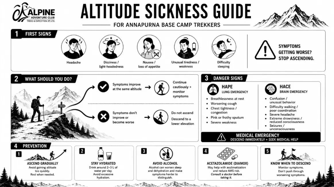
Altitude Sickness Guide for Annapurna Base Camp Trekkers: Symptoms, Emergency Protocols, and Prevention.
Download the infographic (Webp)
This way you'll have the guide offline which will be very helpful during your trek.
Elevation Comparisons With Other Nepal Treks
Annapurna Base Camp vs Everest Base Camp: Elevation Compared
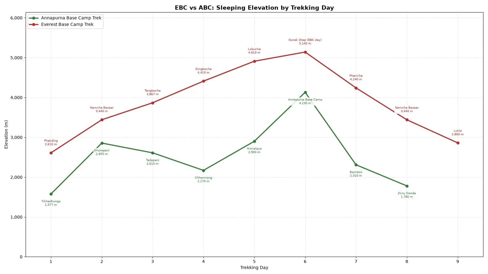
Comparison chart showing daily sleeping elevations for Everest Base Camp and Annapurna Base Camp treks, illustrating differences in route steepness and peak altitude profile.
| Trek | Highest Sleeping Point | Highest Sleeping Elevation |
|---|---|---|
| Annapurna Base Camp | Annapurna Base Camp | 4,130 m (13,550 ft) |
| Everest Base Camp | Gorak Shep | 5,164 m (16,942 ft) |
The elevation of Everest Base Camp is 5,364 m(17,598 ft), which is 1,234 m(4,049 ft) higher than Annapurna Base Camp. In practice, trekkers generally don't spend the night at Everest Base Camp, they hike up to EBC and return back to Gorak Shep the same day.
Everest Base Camp is generally considered harder than ABC trek because the risk of altitude sickness is significantly higher and requires proper acclimatization.
The trek involves sleeping at altitude of over 4,000 m in stops like Dingboche(4,410 m) , Lobuche (4,910 m) and Gorak Shep(5,164 m) for 2-3 days before reaching Everest Base Camp.
Annapurna Base Camp vs Mardi Himal: Elevation Compared
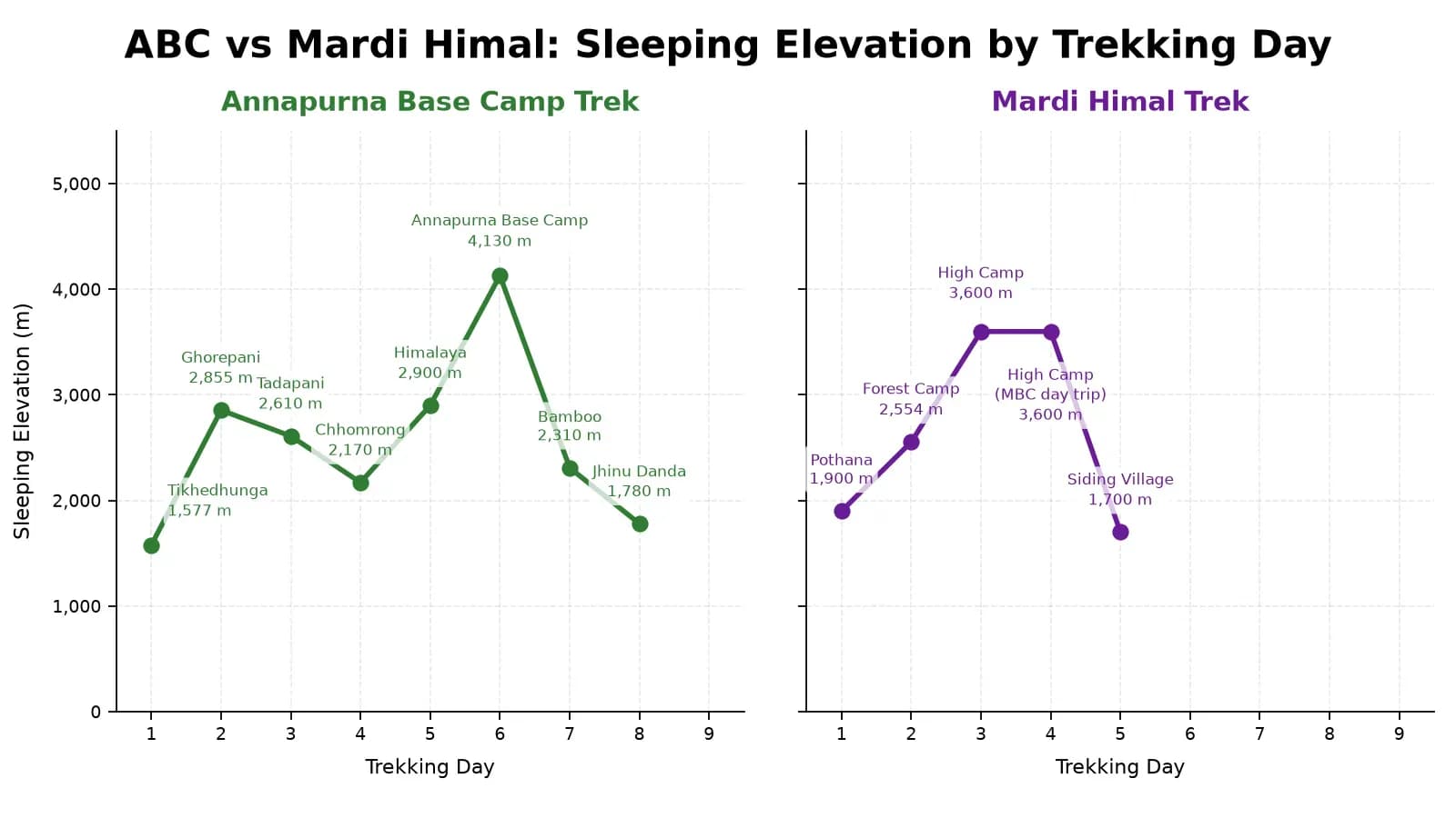
Comparative sleeping elevation charts for the Annapurna Base Camp and Mardi Himal routes, contrasting itinerary lengths, daily gain profiles, and maximum sleeping altitudes.
| Trek | Highest Sleeping Point | Highest Sleeping Elevation |
|---|---|---|
| Annapurna Base Camp | Annapurna Base Camp | 4,130 m (13,550 ft) |
| Mardi Himal | High Camp | 3,550 m (11,647 ft) |
Mardi Himal reaches an elevation of 4,500 m (14,764 ft), which is 370 m higher than Annapurna Base Camp. Even though, the highest point reached on the Mardi Himal trek is higher than the ABC trek, it is generally easier in terms of altitude exposure as it has relatively lower sleeping elevation.
Trekkers typically spend the night at around 3,550 m (11,647 ft), which is 580 m lower than the sleeping elevation at Annapurna Base Camp.
Mardi Himal Trek can be a very good alternative for someone who is looking for shorter trek with less altitude exposure. It provides good panoramic views of Annapurna Range from a high ridgeline, with Machhapuchhre as the standout peak. Whereas Annapurna Base Camp offers more immersive experience, as you are surrounded by Himalayan giants and takes you deep into the Annapurna Sanctuary.
FAQS
Can beginners do the Annapurna Base Camp trek?
Yes, many beginners complete the ABC Trek, but 4,130 m carries a genuine risk of altitude sickness. First-time high-altitude trekkers should ascend gradually, monitor symptoms, and follow appropriate acclimatization practices.
How tall is Annapurna Base Camp in feet and meters?
Annapurna Base Camp stands at 4,130 m (13,550 ft) above sea level. At this altitude, the atmospheric pressure is roughly 60% of sea-level pressure, making the air noticeably thinner.
Is Annapurna Base Camp higher than Everest Base Camp?
No. Everest Base Camp sits at 5,364 meters, over 1,200 meters higher than Annapurna Base Camp's 4,130 meters.
What is the highest altitude on the ABC trek route?
Annapurna Base Camp itself, at 4,130m, is the highest point on the standard trek route.
What is the total elevation gain to Annapurna Base Camp?
The net elevation gain from Nayapul (1,070m) to Annapurna Base Camp(4,130 m) is around 3,060m. Since the route includes multiple ascents and descents, the cumulative elevation gain is much higher. The exact cumulative figure depends on the itinerary and how the routes are measured.
Can you get altitude sickness at Annapurna Base Camp altitude?
Yes. At 4,130m, and with several earlier stops above 2,500 m, AMS risk is real throughout the trek. Ascending gradually, staying hydrated, and monitoring symptoms significantly reduce the risk, though it can affect trekkers regardless of fitness level.
Is Annapurna Base Camp safe at 4,130m for beginners?
Yes, with proper acclimatization. 4,130 m carries genuine altitude-sickness risk for anyone, not just beginner so first-time high-altitude trekkers should follow the same gradual-ascent and symptom-monitoring guidance as experienced trekkers, and shouldn't assume trekking experience alone prevents AMS.
How does ABC elevation compare with the Mardi Himal Trek?
Mardi Himal View Point sits at around 4,500 m (14,764 ft), slightly higher than Annapurna Base Camp's 4,130m, but the Mardi Himal trek is shorter overall with a steeper daily elevation gain in its final stretch.